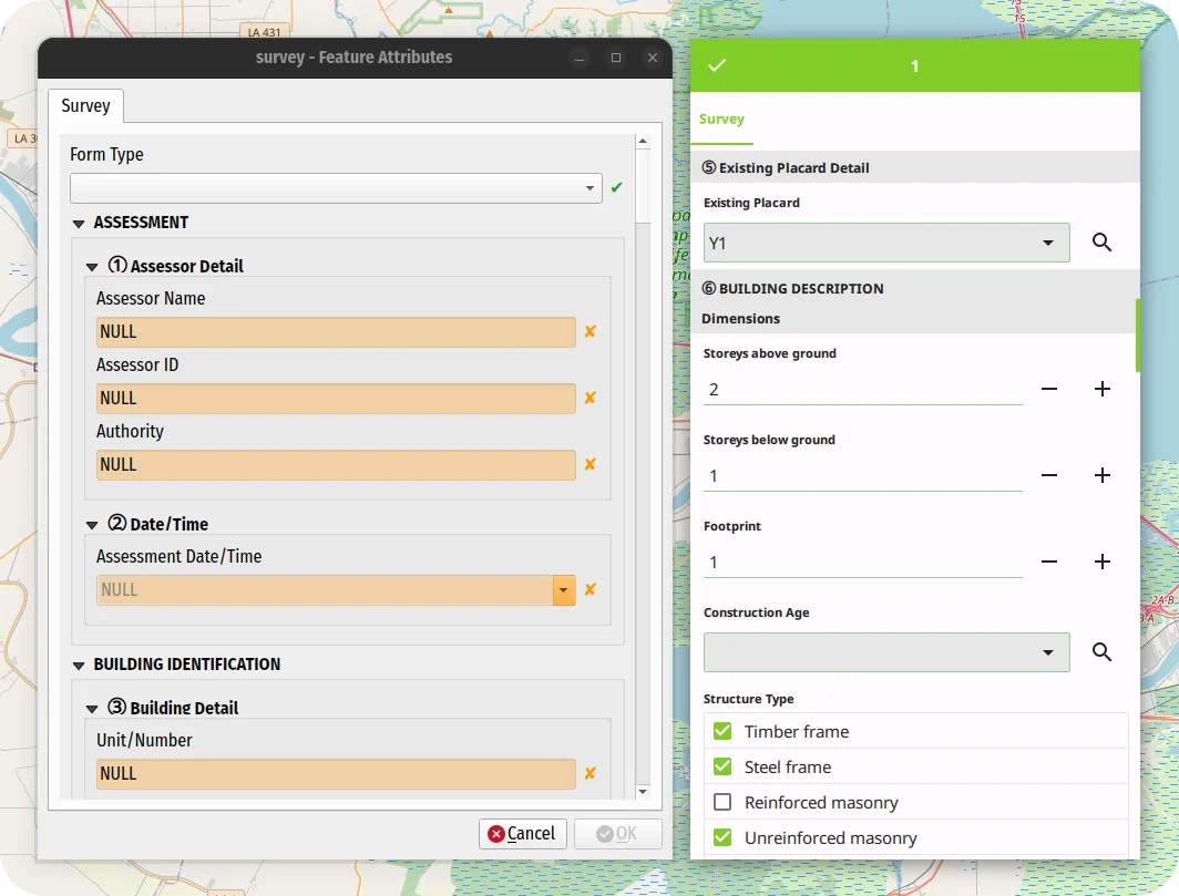
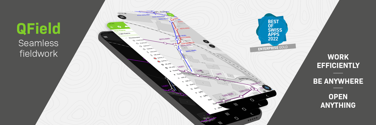
QField 3.7 “Haida Gwaii”: Polishing a great experience
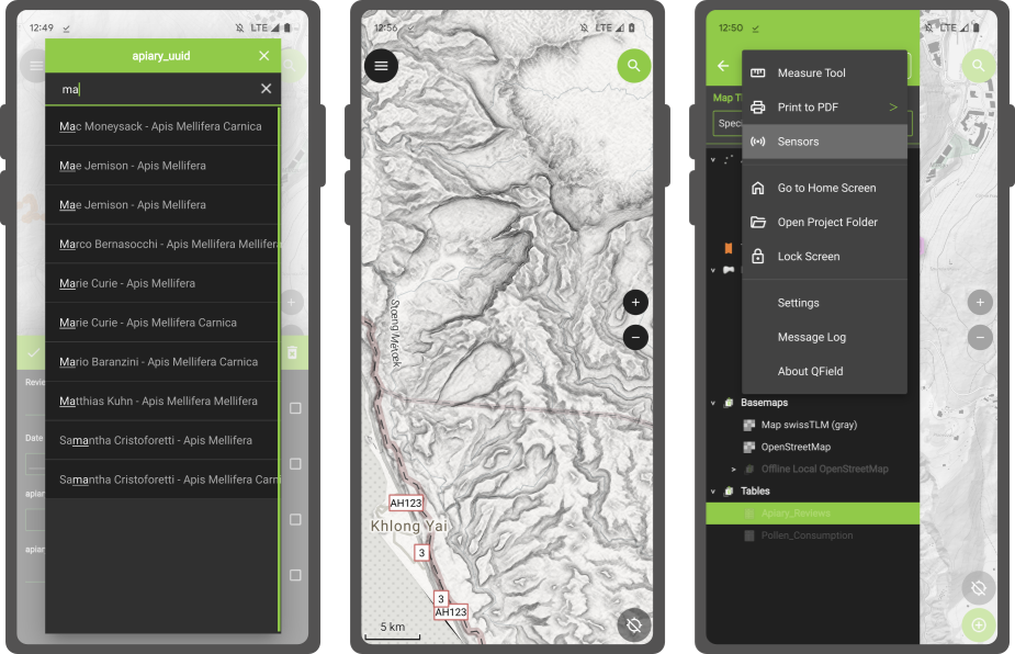
For QField 3.7, we opted for a shorter development cycle that focused on polishing preexisting functionalities from feature form editor widgets improvement through to better nearby Bluetooth device discovery. Of course, we couldn’t help ourselves and still packed in some nice functionality that we thought deserved to reach QField’s growing community as soon as possible.
Main highlights
Celebrating community, innovation, and open-source GIS in Sweden - AKA the QGIS user conference 2025
It was such a pleasure to be part of the QGIS User Conference 2025 in Norrköping! The event was extremely well organised — a big thank you to the amazing local team for pulling it all together so smoothly. Personally, it felt special to be back in Sweden, almost 20 years after my Uppsala university days. I truly enjoyed giving the opening keynote and sharing the latest from the QGIS project — and …
QField 3.6 “Gondwana”: Locking on greatness
Building on top of the last release which introduced background tracking, this development cycle focused on polishing functionalities and building on top of preexisting features. The variety of improvements is sure to make our diverse user base and community excited to upgrade to QField 3.6.
Main highlights
XLSForm Converter: unlock a world of surveys with our brand new QGIS plugin
Today marks the initial release of our brand-new QGIS plugin, XLSForm Converter.
As the name suggests, the plugin converts XLSForm survey files into ready-to-use QGIS projects with a preconfigured survey attribute form.
Migrating to QField was never easier!
1 Million Downloads: QField's Big Milestone
🚀 QField has officially hit 1 million downloads – thanks to you! 🎉
Let’s not beat around the bush: QField has hit 1+ million downloads. What started as an ambitious open-source project has transformed into a global tool that’s changing how professionals collect spatial data in the field. This big milestone is the result of years of dedication, with over 50,000 hours invested by our …
FOSSGIS 2025 – What a Week!
As long time sponsors of FOSSGIS, we stepped up the game this year and became Platinum Sponsors for FOSSGIS 2025. We are proud to be part of a thriving open-source GIS community and to contribute to such a great conference. Here’s a recap of everything we were involved in:
🚀 Talks & Presentations
🌍 QField: New Strategy and Application Potential
Berit and Marco presented how QField, with …
Unpacking key insights from our QField Workshop
This year, OPENGIS.ch celebrated its 10th anniversary in Bern, with an afternoon full of workshops attended by clients, long-term friends, and colleagues. Here, we will give a glimpse of QField: its vision, where it’s headed, and the exciting features future users can look forward to.
QField 3.5 “Fangorn”: Background tracking a reality!
Let’s not bury the lead here: the long-awaited capability to track position while QField is in the background or the device is locked has arrived in this brand-new version of QField. This feels like a magical moment, so we settled for a fantastical forest for our release name.
Main highlights
QField 3.4 “Ebo”: Geofencing and processing out of the box
QField 3.4 is out, and it won’t disappoint. It has tons of new features that continue to push the limits of what users can do in the field.
Main highlights
Rapid Mapping the Ticino Floods and Landslides with QField Rapid Mapper
QField Rapid Mapper is a project for the QField mobile app
, which allows emergency responders, civil protection, military, and citizens to assess and report damages from natural catastrophes by quickly sharing geolocated images, videos and audio. QField Rapid Mapper offers real-time data collection, mapping and sharing to help enhance disaster response and coordination.
QField and QFieldCloud are …
Supercharge your fieldwork with QField's project and app-wide plugins
This blog post will introduce QField’s brand new plugin framework and walk through the creation of a plugin to support bird watchers in need of a quick way to digitize photos of spotted birds onto a point vector layer.
A plugin framework is born!
As announced recently , QField now empowers users through a brand new plugin framework allowing for simple customization on the way the application …
QField 3.3 “Darién”: It is just the beginning
QField 3.3 has been released, and with it, we are proud to introduce a brand new plugin framework that empowers users to customize and add completely new functionalities to their favourite field application. That’s on top of a bunch of new features and improvements added during this development cycle. What preceded this moment was just the beginning!
Main highlights
QField receives prestigious recognition as a digital public good from the Digital Public Goods Alliance
We are thrilled to announce that the Best of Swiss Apps Enterprise winner 2022, QField, has been officially recognized as a Digital Public Good by the UN-endorsed Digital Public Goods Alliance . This prestigious recognition highlights QField’s significant contributions to six key Sustainable Development Goals (SDGs): SDG 6 (Clean Water and Sanitation), SDG 9 (Industry, Innovation, and …
QField background tracking
Years ago, the QField community and its users showed their love for their favourite field app by supporting a successful crowdfunding to improve camera handling.
Since then, OPENGIS.ch has continued to lead the development of QField with the regular support of sponsors. We couldn’t be prouder of the progress we have made, with plenty of new features added in every major release. This includes …
Capturing more while in the field with the new QField 2.7
A brand new version of QField has been released, packed with features that will make you fall in love with this essential open source tool all over again with a focus on capturing more while you are in the field. QField 2.7 nicknamed “Heroic Hedgehog” also includes a number of worthy fixes making it a crucial update to get.
New recording capabilities
QField Jump-start
You want to start collecting field data but never worked with a GIS before?
You are a passionate QGIS user and would like a jump start your fieldwork setup?
You are a senior GIS manager and would like to optimize your teams’ mobile data collection efficiency?
Let us you introduce the QField jump-start packages
During a half day or full day private support session, our QFields experts will …
QField 2.6: perfecting high-accuracy positioning
It’s only been a few weeks into the new year, but we’ve got great news for you: a brand new QField 2.6 “Geeky Gecko ?” has been released with a focus on positioning improvements, including Bluetooth support for Windows. And with that, we are delighted to remove the ‘beta’ status from QField for Windows.
New positioning features
Best of Swiss Enterprise App Award for QField
What a night it was. The “Best of Swiss Apps Awards” took place in Zurich yesterday, November 2, 2022. We were also nominated with QField . And in the enterprise category, the app was so convincing, that it was awarded the highest possible price. So it brought the award “Best of Swiss Enterprise App” home to Graubünden. And as cherry on the cake: QField was also nominated …
QField 2.4 is here, and it is ?icious
Yes, QField for QGIS, the leading fieldwork app, was released on the iOS App Store!
Get It now for Android, iOS, MacOS, Windows and Linux

Good things take time (and sponsors ), and we wanted our Apple users to enjoy the same solid and seamless experience as our Android users. So we took the time needed and ran beta testing of QField for multiple months. Thanks to all the community feedback …
How we build QField for many platforms - A look behind the curtain
In the past year, the build system behind QField has been ported to vcpkg, a modern C++ dependency management system . It has been a great success for QField and considerably helped to streamline efforts, improve the development experience and to guarantee an outstanding stability of the application. In this blog post we will look at the history of building QGIS based applications for mobile …
24th Contributors QGIS Meeting in Firenze 2022
The international community of QGIS contributors got together in person from 18 to 22 August in parallel to OpenStreetMap State of The Map event and right before the FOSS4G . So there was a lot of open source geo power concentrated in the beautiful city of Florence in those days. It was my first participation and all I knew was that it’s supposed to be an unconference. This means, there is …
A New Trick up QField’s Sleeve: Animated Maps
Starting with QField 2.2, users can fully rely on animation capabilities that have made their way into QGIS during its last development cycle. This can be a powerful mean to highlight key elements on a map that require special user attention.
The example below demonstrates a scenario where animated raster markers are used to highlight active fires within the visible map extent. Notice how the …
QField Users Sit Down, We Need to Talk About Storage Access on Android
TLDR: Since November 2021, Google has enforced new storage access limitations for apps published on its Play store which prohibits direct storage access on Android 11 and above forcing QField to adapt and rely on importing projects and datasets to access those.
If you are a QField beta user on Android 11 and above, you might have noticed a significant change in the way the app is handling …
QField collected data crucial in disaster relief after Tonga’s volcanic eruption
For once, it’s not an app from the Silicon Valley, but from Laax in the Swiss Alps that made the news. By publishing QField as an open-source app, OPENGIS.ch allows companies, organisations and even countries without the necessary financial means to have the opportunity to benefit from this important data collection app. And it is being used: Over half a million downloads have already been …
QFieldCloud now opensource - Happy 10 Years of field mapping with QGIS
Today, on QField’s 10th anniversary, we’re extremely proud to publish the results of over 18 months of development and give you the source code of QFieldCloud to go and make your awesome adaptations, solutions, and hopefully contributions :)
If you want to quickly try it out, head to https://qfield.cloud where our hosted solution is running and secure yourself a spot in the beta …
Powerful and gentle QField 1.8 Selma sneaked in
Get fieldwork smoothly and nimbly done despite the ice and snow outside. Collect accurate data with freehand digitizing and improved form widgets, use the data from your external GNSS receivers without any third-party apps and enjoy the pleasant usability of QField 1.8 Selma.
This year started off hi-speed for us. There’s been already a lot of coding, designing and teaching, and we’ve …
QField 1.7 Rockies hits the stage
Be ready for the cold weather with a smooth coordinate search, filters in the value relation widget, fancy new QML and HTML widgets, enhanced geometry editing functionalities and an expandable legend. Right when Autumn starts, QField 1.7 Rockies hits the stage.
As usual get it now on the play store or on github !
The days are getting shorter and the wind blows colder. It’s always good to be …
QField 1.6 is out!
Editing multiple features at the same time, support for stylus pens, dynamic configuration of image names and much more.
QField 1.6 Qinling 秦岭 comes packed with awesome new features and an improved user experience.
We have been very busy over the last few months working on a new and shiny QField release. We have added many new features that increase efficiency on the field or allow for new …
Offline WMS - Benchmarking raster formats for QField
What are we looking for?
We would like to use WMS offline on QField. For that, we need to figure out what is the best way to get a raster from a WMS and which format is the most efficient (size and performance).
In this post we’ll show you is how to generate the ideal raster file from a WMS and the results of our efficiency tests for the the different raster formats.
QField 1.4 released - Happy new year
What a year’s start! After a very packed December publishing all the QGIS on the road videos and quietly releasing QField 1.3 - Ben Nevis we could have gone and relaxed over the holidays. But since we love QField so much we immediately started working on the next iteration. Now, after an intensive testing period, we are proud to announce the release of QField 1.4 - Olavtoppen.
Olavtoppen!? …
QField 1.2 released
After an intensive testing period, we are proud to announce the release of QField 1.2
As usual, get it on play store or download it from GitHub.
QField Crowdfunding Campaign
Before digging into all the new goodness that you will find in QField 1.2, let’s get some big “Thanks” out. What QField currently is was mostly possible thanks to customer projects of which the outcome …
Win a QField jump-start package, use #MyQField
Do you want to win a QField jump-start package worth 550€?
We are launching the # MyQField challenge. Follow us on Twitter and show us how you use @ QFieldForQGIS by tagging your tweets with # MyQField and # dataisoutside . The tweet with most likes and retweets by 24.4.19 wins the training!
Rules
- You need to follow @ OPENGISch and @ QFieldForQGIS
- Likes count single, retweet count double …
QField 1.0 is here
Let’s get straight to the point
It’s official, QField for QGIS 1.0 is out!
Get it while it’s hot on the Playstore ( qfield.org/get ) or on GitHub
We are incredibly pleased and proud of just having released such a jewel and are convinced that, thanks to all its features and conscious design choices, QField will make your field digitizing work much more efficient and pleasant.
Packed …
GeoBeer #26 in Bern hosted by OPENGIS.ch
Last Thursday around half past six in the evening. Striking many Geo-scientist found the way to the Spitalgasse in Bern. The reason was the 26th GeoBeer event taking place at [ImpactHub](https:// https://bern.impacthub.net/)
.
[GeoBeer](https:// https://www.geobeer.ch
) is a quarterly meeting of people interested in geography, GIS, cartography and the latest technologies. It’s hosted every …
QField RC5 - Last call for testing
We are really happy to announce the fifth and (hopefully) last 1.0 release candidate in QField’s history! This means that QField 1.0 is closer than ever.
Get it while it’s hot on the Playstore ( https://qfield.org/get ) or on GitHub
Thanks to all the feedback by the fantastic community we were able to fix plenty of bugs, address performance issues and even add some super cool new …
You gave us feedback - we give you QField 1.0 RC3
We are really happy to announce the release a new great milestone in QField’s history, QField 1.0 Release Candidate 3! (Yes, you might have got a glimpse of the broken RC2 if you where very attentive)
Thanks to the great feedback we received since releasing RC1 we were able to fix plenty of issues and add some more goodies.
We would like to invite everybody to install this Release Candidate …
New Year's present - QField 1.0 RC1
It was a long and winding road but we are very excited to announce the general availability of QField 1.0 Release Candidate 1.
Packed with loads of useful features like online and offline features digitizing, geometry and attributes editing, attribute search, powerful forms, theme switching, GPS support, camera integration and much more, QField is the powerful tool for those who need to edit on …
How to filter features in QGIS using the graphical processing modeler
This article describes a new algorithm for the processing modeler called feature filter algorithm. If you are already familiar with ETL concepts and the graphical modeler, you can directly jump to the section the feature filter algorithm .
Building workflows for repetitive tasks
When building workflows for simple or complex geodata infrastructures, one of the most common tasks one encounters is to …
PostgreSQL back end solution for quality assurance and data archive
Did you know that the possibilities to make a full QGIS back end solution for quality assurance and archiving in PostgreSQL are immense? SQL has it’s well known limitations, but with a little bit creativity you can make quite nice solutions just using triggers and rules. In this post I’ll explain what we did lately based on a project with a customer. He needed to assure the consistency …

QGIS Mobile 0.2 Demo
QField (formerly known as QGIS Mobile) is a touch optimized interface for field work developed by OPENGIS.ch. It is with great pleasure the we want to share with you the demo video of version 0.2. Since the project is going to be one of our core projects, we set up a dedicated page here . The QGIS mobile 0.2 video demonstrates some basic functionality like navigation, feature identification and …
Happy new year to the power of two!
For the first time we at OPENGIS.ch can celebrate with 2 people, Marco Bernasocchi and Matthias Kuhn both experienced QGIS developers and holders of a Master degree in GIScience. After having worked individually in the last years, we have realized that there is a huge potential for us to join our knowledge - because the whole is greater than the sum of its parts. This is why starting from January …