Celebrating community, innovation, and open-source GIS in Sweden - AKA the QGIS user conference 2025
It was such a pleasure to be part of the QGIS User Conference 2025 in Norrköping! The event was extremely well organised — a big thank you to the amazing local team for pulling it all together so smoothly. Personally, it felt special to be back in Sweden, almost 20 years after my Uppsala university days. I truly enjoyed giving the opening keynote and sharing the latest from the QGIS project — and …
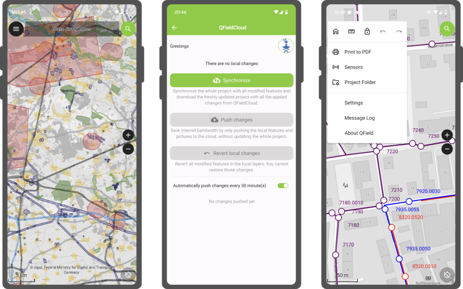
QField 3.6 “Gondwana”: Locking on greatness
Building on top of the last release which introduced background tracking, this development cycle focused on polishing functionalities and building on top of preexisting features. The variety of improvements is sure to make our diverse user base and community excited to upgrade to QField 3.6.
Main highlights
FOSSGIS 2025 – What a Week!
As long time sponsors of FOSSGIS, we stepped up the game this year and became Platinum Sponsors for FOSSGIS 2025. We are proud to be part of a thriving open-source GIS community and to contribute to such a great conference. Here’s a recap of everything we were involved in:
🚀 Talks & Presentations
🌍 QField: New Strategy and Application Potential
Berit and Marco presented how QField, with …
24th Contributors QGIS Meeting in Firenze 2022
The international community of QGIS contributors got together in person from 18 to 22 August in parallel to OpenStreetMap State of The Map event and right before the FOSS4G . So there was a lot of open source geo power concentrated in the beautiful city of Florence in those days. It was my first participation and all I knew was that it’s supposed to be an unconference. This means, there is …
A New Trick up QField’s Sleeve: Animated Maps
Starting with QField 2.2, users can fully rely on animation capabilities that have made their way into QGIS during its last development cycle. This can be a powerful mean to highlight key elements on a map that require special user attention.
The example below demonstrates a scenario where animated raster markers are used to highlight active fires within the visible map extent. Notice how the …
Offline WMS - Benchmarking raster formats for QField
What are we looking for?
We would like to use WMS offline on QField. For that, we need to figure out what is the best way to get a raster from a WMS and which format is the most efficient (size and performance).
In this post we’ll show you is how to generate the ideal raster file from a WMS and the results of our efficiency tests for the the different raster formats.
QField 1.4 released - Happy new year
What a year’s start! After a very packed December publishing all the QGIS on the road videos and quietly releasing QField 1.3 - Ben Nevis we could have gone and relaxed over the holidays. But since we love QField so much we immediately started working on the next iteration. Now, after an intensive testing period, we are proud to announce the release of QField 1.4 - Olavtoppen.
Olavtoppen!? …
QField 1.0 is here
Let’s get straight to the point
It’s official, QField for QGIS 1.0 is out!
Get it while it’s hot on the Playstore ( qfield.org/get ) or on GitHub
We are incredibly pleased and proud of just having released such a jewel and are convinced that, thanks to all its features and conscious design choices, QField will make your field digitizing work much more efficient and pleasant.
Packed …
GeoBeer #26 in Bern hosted by OPENGIS.ch
Last Thursday around half past six in the evening. Striking many Geo-scientist found the way to the Spitalgasse in Bern. The reason was the 26th GeoBeer event taking place at [ImpactHub](https:// https://bern.impacthub.net/)
.
[GeoBeer](https:// https://www.geobeer.ch
) is a quarterly meeting of people interested in geography, GIS, cartography and the latest technologies. It’s hosted every …
You gave us feedback - we give you QField 1.0 RC3
We are really happy to announce the release a new great milestone in QField’s history, QField 1.0 Release Candidate 3! (Yes, you might have got a glimpse of the broken RC2 if you where very attentive)
Thanks to the great feedback we received since releasing RC1 we were able to fix plenty of issues and add some more goodies.
We would like to invite everybody to install this Release Candidate …
How to filter features in QGIS using the graphical processing modeler
This article describes a new algorithm for the processing modeler called feature filter algorithm. If you are already familiar with ETL concepts and the graphical modeler, you can directly jump to the section the feature filter algorithm .
Building workflows for repetitive tasks
When building workflows for simple or complex geodata infrastructures, one of the most common tasks one encounters is to …
PostgreSQL back end solution for quality assurance and data archive
Did you know that the possibilities to make a full QGIS back end solution for quality assurance and archiving in PostgreSQL are immense? SQL has it’s well known limitations, but with a little bit creativity you can make quite nice solutions just using triggers and rules. In this post I’ll explain what we did lately based on a project with a customer. He needed to assure the consistency …
