Outdated documentation
The latest documentation was moved to docs.qfield.org
地方水衛生局(RWSS), 上下水道公社 (WASAC), ルワンダ
ルワンダにおいて全ての地方給水施設のデータ収集を行い、継続的にデータの更新を行うことで、水道施設の運営維持管理に寄与する。
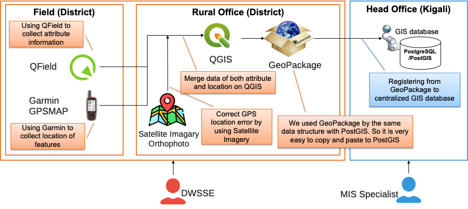
Android端末を準備するのとは別に、より高精度な測位をするためにGPSデバイスを購入しました。WASACでは、Garmin GPSMAP 64Sを調達しました。スマートフォンやタブレットのGPSはたまに精度が良くないことがあるので、通常はGarmin GPSを用いて同じ場所の位置を取得し、データ収集後のQFieldでの位置情報を補完しています。
GeopackageとQGISプロジェクトのテンプレートの準備ができたあと、2018年7月にQGIS/QFieldのトレーニングを実施し、ルワンダ全国の27郡でのデータ収集に着手しました。27名のエンジニアが集めたGeopackageをキガリの本部に送り、MIS (Management Information System)スペシャリストが彼らのデータをチェックしGeopackageからPostGISデータベースに入力します。このデータ収集は2019年4月までに完了しました。
データ収集後最も重要なことは``更新``です。アフリカの多くの組織ではデータの継続的に更新がうまくできずに、数年後には彼らのデータが非常に古くなっており、また同じデータ収集に着手せざるを得ないというケースが多いです。
WASACは全てのデータを継続的に更新していくことを決め、現在に至るまでデータを更新し続けています。QFieldはこの目的のためにとても最適なものであることを保証します。
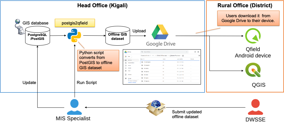
データを配布し、更新していくためには、WASACでは postgis2qfield というPythonスクリプトを開発しました。この postgis2qfield ツールはPostGISからデータを取り出し、ルワンダの各郡ごとのGeopackageを生成することができます。それら27個のGeopackageをQGISプロジェクトのテンプレートと一緒にGoogleドライブにアップロードします。それから、各郡のエンジニアがGeopackageを自分たちのアンドロイドのダウンロードしデータの追加更新を継続します。データの更新が終わったら、再度Geopackageを本部に送り、MISスペシャリストがPostGISデータベースを更新し、QField用のGeopackageを再生成します。
まず、 こちら から私たちが収集したデータをご覧いただけます。
2020年7月から、給水システムのデータをベクタータイルを用いたオープンデータとして配信し始めました。ルワンダのインターネットの環境は改善しつつありますが、いくつかの地方部ではまだインターネットに課題があります。このような脆弱なインターネット環境においては、WMSやWFSのようなデータ配信はうまく機能しません。ベクタータイルを使うことで軽量かつ高速な地図データの配信をできます。ここではこれ以上私たちのベクタータイルの仕組みについては述べません。もしデータ収集結果の共有方法についてご興味がありましたら、こちらの インストラクション をご覧ください。
データ収集作業を行なってくれた全郡の水衛生支援エンジニアに感謝いたします。また、QFieldとQGISの開発者の方にも、このような素晴らしいオープンソースソフトウェアを提供してくれていることに感謝いたします。こういったフリーのソフトウェアがあるおかげで、開発途上国の水セクターの一組織がこのようなプロジェクトを行えるのはとても素晴らしいことです。
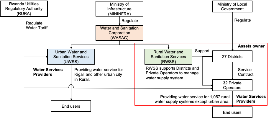
WASAC は都市給水(UWSS)と地方給水(RWSS)2つの主な部署を有しています。QFieldを使っているのはRWSSになります。RWSSの役割としては地方部で給水施設を所有し運営維持管理を行なっている地方政府を支援することです。今では、RWSSによって収集され維持されているこれらのデータは、27郡の30以上の民間に委託された事業者によって利用されています。データベースにある水道システムは合計して1000以上になります。
また、私たちの同僚の一人がWASACの活動についてFOSS4G 2019 ブカレストで発表を行いました。現在のシステムとは一部変更された点もありますが、ご興味がありましたら、 ビデオ をご覧いただければと思います。