Trusted Mobile GIS for Peacekeeping and Humanitarian Response
The United Nations Open GIS Initiative, a global partnership led by the UN Geospatial Operations team, has officially recognized QField as a recommended open-source solution for mobile geospatial data collection in UN field operations.
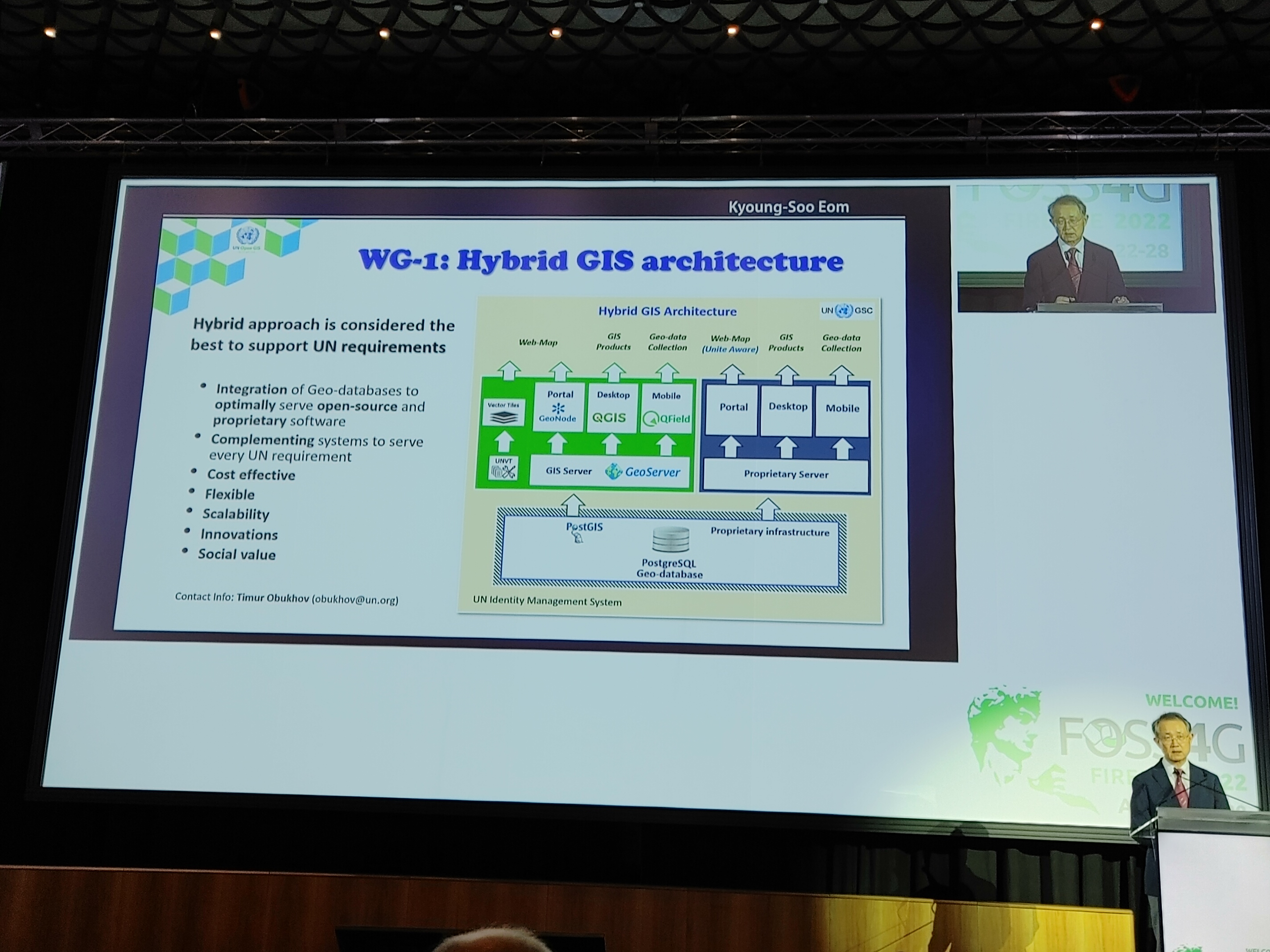
As part of its commitment to building a modern, scalable, and cost-effective open geospatial infrastructure, the Initiative evaluated several open-source tools and identified QField as a robust and flexible mobile platform well-suited for the realities of UN peacekeeping and humanitarian missions.
Why QField?
Field-tested by GIS teams in missions such as UNMISS (South Sudan) and MONUSCO (DR Congo), QField proved highly effective for collecting, editing, and managing geospatial information in low-connectivity and challenging environments.
Its tight integration with QGIS, offline-first design, and customizable forms made QField a preferred solution in the Geo-Data Collection Working Group. In combination with PostgreSQL/PostGIS and GeoServer, QField helps field officers collect accurate, structured, and synchronized data across the UN’s global operations.
Key Benefits for UN Missions
- Reliable offline operation in low-bandwidth and remote settings
- Direct synchronization with centralized UN Spatial Data Infrastructure
- Support for custom forms, photos, UUIDs, and quality assurance
- Open licensing, enabling capacity-building and technology transfer
🛰️ UN Recognition for QField’s Strategic Role
“QField has been spotlighted by the UN Open GIS Initiative as a crucial part of their hybrid GIS system. This recognition underscores QField’s superior capabilities in supporting multiple United Nations Sustainable Development Goals (SDGs) and revolutionizing geospatial data collection.”
This endorsement reflects the UN’s confidence in QField as a scalable, flexible, and mission-critical mobile application capable of serving a wide range of geospatial needs — from emergency operations and environmental monitoring to infrastructure mapping and humanitarian support.
Beyond Software: Capacity Building and Openness
In alignment with the UN’s open-source strategy, QField has been integrated into training curricula for GIS officers across multiple UN agencies. The Initiative emphasized not only deploying tools, but also building local capacity and skills — with over 120 UN staff trained in QGIS and QField through collaborations with Politecnico di Milano and OSGeo’s GeoForAll network.
A Global Signal for Open Source
By choosing QField and other FOSS4G tools as part of its official technology stack, the UN Open GIS Initiative sends a strong message to governments and humanitarian actors worldwide: open, mobile-first geospatial tools are ready for mission-critical deployments.